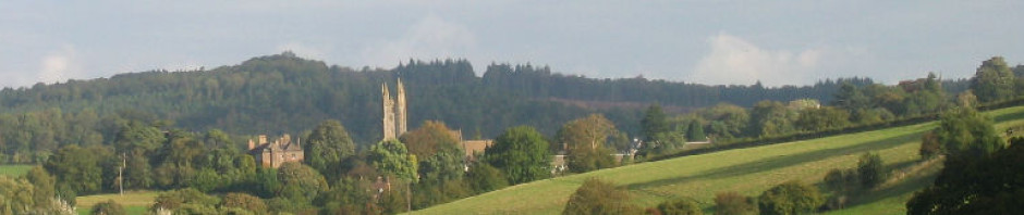
In the UK we have a long history of excellent map making from the OS (Ordnance Survey) who first mapped out the country in the 18th century for military purposes, hence their slightly odd name.
OS 1:25K
Domestic maps used by most UK walkers come in 1:50,000 scale and 1:25,000 scale, but most GPSr manufacturers only sell the less detailed 1:50K version, usually for around £200 for the entire UK. Those that sell 1:25K mapping usually only have national parks available and they tend to cost about £100 for each map covering a single park. To get the whole UK (if possible) would cost thousands of pounds. Add to this that Garmin Discoverer maps are of pretty poor image quality. If you zoom in too much they become become blurred because the image resolution is too low. Another disadvantage is that Garmin and Magellan license these maps to a single device and you can’t backup and restore the maps to another microSD card. If you lose / break the device or the SD card you need to buy new maps. “Rip off”, I hear you say. You are indeed correct.
All you need is free MOBAC (MOBile Atlas Creator) 1.9 beta or earlier. It’s not hard to find. Torrents are a good source if you are familiar with them. It’s perfectly legal. The reason you need an old version is that the developer removed many of the data sources after this version including the Ordnance Survey data source. They can be added manually, but this is the easiest way. That’s it, there’s no other software required.
Install Mobac and run it. If you select Ordnance Survey Explorer Maps (UK), you should see something like this.
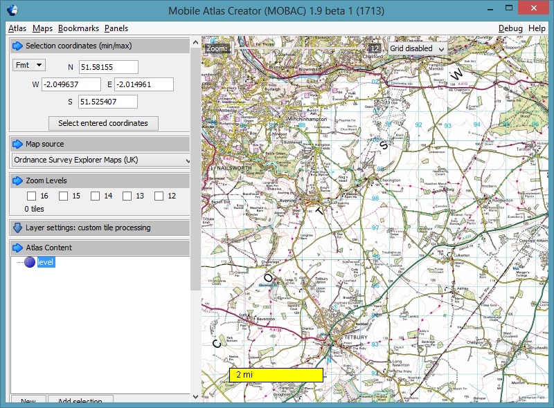
Click sample for full image
Play with the zoom (near top of map). Each map source has different zoom levels available to it. The OS maps here are available from 12 to 16. You can only zoom out to 12, so you can’t see a huge area. Note where 1:50K maps turn to 1:25K maps (red paths to green paths etc). Select the Bing Maps map source. Bing Maps has maps for levels 1 to 19 so you can zoom in or out much more. Of course the map detail doesn’t compare to the OS maps.
Raster maps are basically calibrated images (your paper OS map
in digital form), whereas vector maps are just a bunch of numbers
that can be interpreted by your device to display digital maps.
Vector maps are required by sat nav so that a route can be
calculated. With a raster map the device will not know what is
road, sea or field. It's all just pixels to the them.
A secondary advantage of vector maps is that you can hide data
when you zoom out to avoid clutter. Raster maps get round this
issue by having separate maps for each zoom levels. Raster maps
are generally much more detail and prettier too. They are what we
walkers need. We generally don't care about routing on roads.
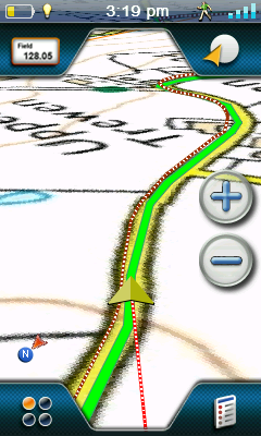
OS 1:50K
RMP maps can consist of one or more zoom levels. The device is clever enough to use the map level that corresponds to how far you are zoomed in regardless of whether the levels are in the same file or in multiple files. I chose to generally use a separate RMP file for each level rather than incorporate all maps for an area into a single file. This means a low level map can cover a huge area and smaller areas are covered by maps with higher zoom levels as they contain more detail.
We will use Bing Maps to manually select the area for our 1:50K map (as it will allow the whole area to display on the screen) before switching to OS maps before we grab the data. If you choose only level 14 like I did you will be able to divide the UK into Wales, England (SW, SE, Central, E, N) and Scotland (Lowlands, Central, NW, NE). See how I divided it here.
To make a level 14 OS map of Wales:
- Select map source Bing Maps and zoom out so you can see the whole of Wales.
- Left click mouse to select a corner of the rectangle enveloping Wales.
- Keep the button pressed and release when the cursor is at the opposite corner of the required rectangle. Your selected area will be pink.
- Once you are happy you have the area you want selected do NOT click on the map again as the coordinates will be lost. You can right click to move the map though.
- Change map source to OS Explorer Maps (UK) and select the tickbox for zoom level 14.
- Click New in Atlas Content and select Magellan (RMP) to specify the output map format
- Click Add selection (underneath Atlas Content) to add the selected levels to the map.
- Click on the Create Atlas button. This small map should typically take about 5 minutes to download and create, but it obviously depends on your data pipe and PC performance.
- When completed rename the file to a standard. i.e OS 1-50K Wales.rmp or similar.
- Finally move it to where you plan to keep your maps.
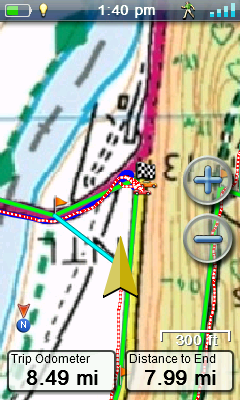
OS on sat nav. You also need the Magellan vector map (comes with eX710) for this to work
You can test the map out on the device by copying to the Maps folder on either the internal memory or on your SD card. Don’t forget to select the map in the eXplorist map menu. Of course you will have to zoom to an appropriate level to see it too.
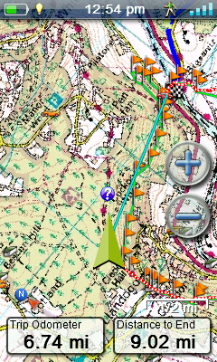
To view it in VantagePoint select Maps and click Add (plus sign) and select the file. I found this process susceptible to crashing the application. If it does, just do it again. After loading 3 or 4 maps I close/re-open VP so I don’t lose the changes. You can see an example of my 1:50K map in VantagePoint here. Notice how much of the map is visible, unlike Garmin applications that restrict your viewing area to a tiny window.
If you’re happy with the map you need to complete the other level 14 maps for the rest of the UK ensuring there is a slight overlap between maps. In my example the Scottish Lowlands are not really required.
Before we do the more complicated 1:25K maps lets quickly cover off the lower scale maps.

UK divided roughly into 0.8° “squares”
Level 12 was covered by two OS maps, one of England and Wales and the other covered Scotland. None of my maps cover Northern Ireland as a) I don’t want these maps and b) the OS don’t cover N. Ireland. I also made an overview map (mostly for VP). This covers the whole of the UK using Bing Maps levels 4, 6, 8 and 10.
If you want to get maps for a large area, like the whole of the UK, you need to plan how you will divide your maps up. Each map can not be larger than 2GB. Most of mine were 500-600MB and they perform perfectly on the device with no slow downs at all. I got a map of the UK and drew a grid over it spacing the lines 0.8° on the horizontal and vertical (they don’t appear square because we are a fair distance from the equator) and then juggled some boundaries along the coastline where it made sense. I then numbered each square sequentially. This was the basis for my 1:25K maps. I would then build the map using just level 16 OS maps. Using the Selection Coordinates (top left in Mobac) you can precisely select the desired map square. Use Bing map source to view it

Garmin Discoverer gets blurred when zoomed in and it’s only 1:50K
first before changing to the OS map source. Name the files to a standard again, like OS 1-25K 01 Penzance.rmp and OS 1-25K 59 Loch Ness.rmp. If you have a large enough microSD card you could carry around all of your maps on the eX710, though I would tend to just carry the ones I am likely to use and copy others over on rare visits to Scotland and the like.
Note that all Magellan screen shots are oversized, so images will appear even clearer on the device. All Magellan shots have map orientation configured with track up (as opposed to north up), so the map is automatically rotated so you are always heading towards the top of the screen. This is silky smooth and is more demanding on the graphical capabilities, but is also handled well.
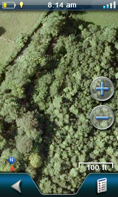
Google Earth is good for spotting tracks in forests
I have also made simple Bing maps of France and have selected level 18 Google Earth satellite imagery maps which works beautifully in conjunction with the OS maps. Level 18 comes in when you have a zoom scale of 100′ or less on the unit. I wouldn’t want to make these for the whole of the UK though as the data volumes would be huge. My test map was about 12 miles square as was 1GB in size.
All of these maps can also be theoretically made for Garmin devices too (not RMP format though), the big difference is that Magellan allow a free reign while Garmin impose tight restrictions and provide poor rendering performance. Garmin only allow 100 jpegs (Montana allows 500) and each jpeg can be (wait for it..) a maximum of 3K. This makes Garmin pretty much useless in the custom map department. Read here about how Garmin users report map rendering of tiny image files to be very slow and jerky. I made some KMZ custom maps before I returned my Garmin Oregon. They were very disappointing. It’s all good news if you are an eXplorist owner though, so have fun!
Hi, thanks for the great post. Please could you explain a bit more about how you split up the UK to get 16 zoom level OS maps? Whenever I try I get 18000×18000 max size error?
Thanks.